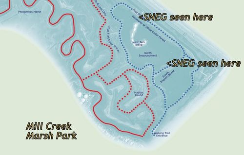
Mary Jo Marino, the "Harbor Herons" volunteer was spotted the banded Snowy Egret, was nice enough to show on a map where she saw the bird.
She adds: "The bird was in the North Impoundment. I first sighted him near the foot bridge. He then flew to the area east of Least Tern Island, and then later over near the border between North Impoundment and South Impoundment.
"This bird was banded on Hoffman Island. The theory is that most of these birds forage in Raritan Bay area. However, here's this young guy out in Secaucus, the area that's supposed to be frequented by the birds from North and South Brother Islands. Go figure." (Thanks, Mary Jo!)
Scroll down for earlier post.


It would be very helpful if we could have a photo of a banded bird posted, so that we know where on the leg the band it is placed. This way we will know if there even a point looking at birds that are wading in water above the knee ….
I’m like you write something, you say good!